


Paris, 1807 (atlas) - 1808 (text).
2 large 4to + 1 folio. All three volumes bound in contemporary half calf with gilding to spines - text volumes uniform.
TEXT: Volume 1 with a split front hinge, but block still tight. A patch of paper missing from back board. Both volumes with some edge wear and bumped corners. Old paper labels to inside of front boards, and a stamp to half-titles and title-pages. A bit of brownspotting, but mostly marginal. Overall, most text-leaves are clean and bright. The plates in vol. 1 have some, mostly marginal, brownspotting. Both volumes with wide margins. Some of the text is printed on blue-ish paper. (4), LVI, 704 pp. & 32 folded engraved plates + (4), VIII, 691 pp. & 1 folded plate. Many tables with astronomical observations. In all 33 folded plates.
ATLAS: Wear to extremities and bumped corners. Inner front hinge re-enforced. Top right blank corner of title-page repaired, far from affecting text. A stamp to title-page. A bit of brownspotting, mostly marginal. The last ab. 10 maps with a damp stain in the middle. The reast are very nice and bright. 4 (title-page + contents-leaf) pp. & 39 maps and charts, 29 of which are double-page.
Fully complete with all 33 folded plates in the text-volumes and all 39 maps and charts in the atlas-volume.
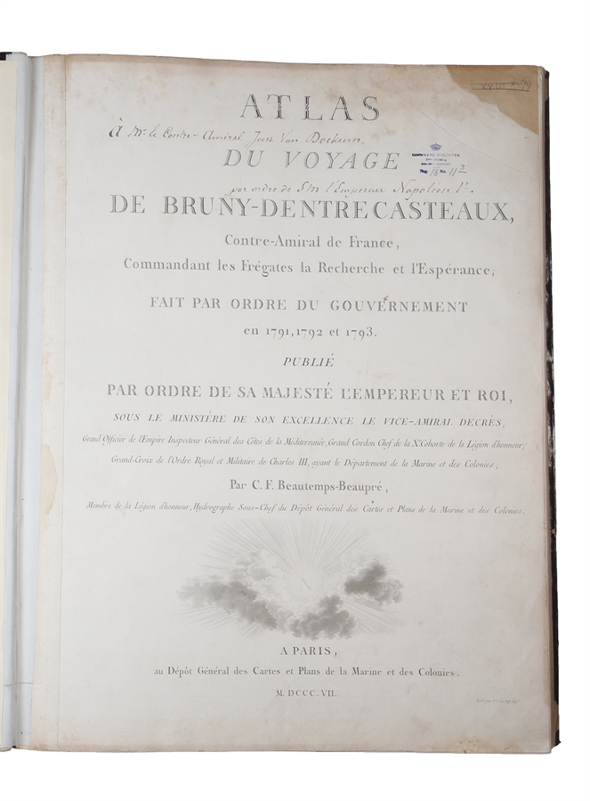
A contemporary handwritten note to the title-page of the atlas stating that THE COPY WAS GIVEN TO ADMIRAL VAN DOCKUM AT THE ORDER OF NAPOLEON I. ("à Mr. le Conte-Admiral Joost Van Dockum,/ par ordre de Sm l'Empereur Napoléon 1e.")
A gift-copy, ordered by Napoleon I - for the Danish admiral that had earned himself great personal admiration from Napoleon - of the first edition of this magnificent travel account, which is famous for its exploration of the Australian coast while searching for the lost Pérouse expedition that had vanished in Oceania.
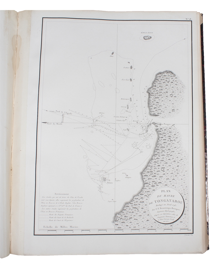
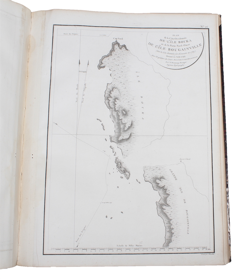
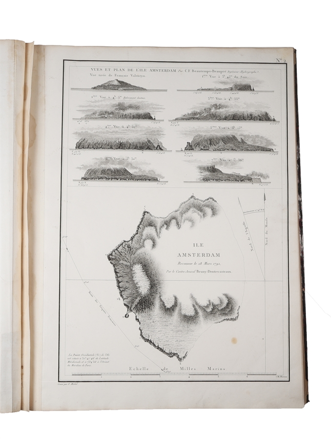
The excellent maps and charts of this foundational publication are made by the expedition's first hydrographical engineer, C.F Beautemps-Beaupré, who is now regarded as the father of modern French hydrography, due to his work on the present expedition. The charts published here, in the atlas volume under the title "Atlas du Voyage de Bruny-Dentrecasteaux", in 1807 were very detailed and remained the source of the English charts of the area for many years. Those of Van Diemen's Land were the exceptionally detailed and have contributed greatly to our knowledge of the area.
In September 1791, the French Assembly decided to send an expedition in search of Jean-François de La Pérouse, who had not been heard of since leaving Botany Bay in March 1788. Bruni d'Entrecasteaux was selected to command this expedition and was given a frigate, Recherche with Lieutenant Jean-Louis d'Hesmity-d'Auribeau as his second-in-command, Rossel among the other officers, and Beautemps-Beaupré as hydrographer of the expedition.
On September 28, the expedition left Brest. The plan of the voyage was to proceed to New Holland in Australia, to sight Cape Leeuwin, then to hug the shore closely all the way to Van Diemen's Land (Tasmania), inspecting every possible harbour in a rowing boat, and then to sail for the Friendly Islands (Tonga) via the northern cape of New Zealand (allowing gardener Félix Delahaye to collect live breadfruit plants for transport to the French West Indies). After that, D'Entrecasteaux was to follow Pérouse's intended route in the Pacific.
However, when Bruni d'Entrecasteaux reached Table Bay, Cape Town on 17 January 1792, he heard a report that Captain John Hunter (later to be Governor of New South Wales) had recently seen - off the Admiralty Islands - canoes manned by natives wearing French uniforms and belts. Although Hunter denied this report, and although the Frenchmen heard of the denial, Bruni d'Entrecasteaux determined to make directly to the Admiralty Islands, nowadays part of Papua New Guinea, taking water and refreshing his crew at Van Diemen's Land. On 20 April 1792, that land was in sight, and three days later the ships anchored in a harbour, which he named Recherche Bay. For the next five weeks, until 28 May 1792, the Frenchmen carried out careful boat explorations which revealed in detail the beautiful waterways and estuaries in the area.
Beautemps-Beaupré, while surveying the coasts with Lieutenant Crétin, discovered that Adventure Bay was on an island, separated from the mainland by a fine navigable channel. On May 16, d'Entrecasteaux commenced to sail the ships through the channel and succeeded in 12 days. Port Esperance, the Huon River, and other features were discovered, named, and charted, the admiral's names being given to the channel (D'Entrecasteaux Channel) and the large island (Bruny Island) separated by it from the mainland.
On May 28, 1792 the ships sailed into the Pacific to search for La Pérouse. On June 17, they arrived off the Isle of Pines, south of New Caledonia. From there, d'Entrecasteaux sailed northward along the western coast of New Caledonia. (The Bruni d'Entrecasteaux reefs at the northwestern end of the New Caledonia Barrier Reef are named for him.) He then passed the Solomon Islands along their southern or western coasts, sailed through Saint George's Channel between New Ireland and New Britain, and on July 28 sighted the south-east coast of the Admiralty Islands. After that he set sail for Ambon (in modern-day Indonesia), where his ships replenished their stores.
Leaving Amboina on October 14, Bruni d'Entrecasteaux made for Cape Leeuwin, the south-western extremity of Australia, to carry out his original instructions of searching southern New Holland for La Pérouse. On December 6, land was sighted near Cape Leeuwin, and named "D'Entrecasteaux Point". They ended up sailing further east and penetrated numerous islands and dangerous shoals, to which they gave the name "D'Entrecasteaux Islands" (later changed to the Recherche Archipelago).
After a violent storm in December, the ships continued eastward to the head of the Great Australian Bight, and on January 4, 1793, Bruni d'Entrecasteaux was forced to leave the coast at a position near Bruni d'Entrecasteaux Reef and sail direct to Van Diemen's Land (this decision was unfortunate, for if he had continued his examination of the southern coast of New Holland, he would have made all the geographical discoveries that fell to the lot of Bass and Flinders a few years later. If that had been the case, a French "Terre Napoléon" might well have been a fact).
The ships anchored in Recherche Bay on 22 January, and the expedition spent five weeks in that area, watering the ships, refreshing the crews, and carrying out explorations into both natural history and geography. Beautemps-Beaupré, in company with other officers, surveyed the northern extensions to Storm Bay - the western extension was found to be a mouth of a river which received the name Rivière du Nord (it was renamed the Derwent River a few months later by the next visitor to this area).
On February 28, d'Entrecasteaux sailed from Van Diemen's Land towards the Friendly Islands, sighting New Zealand and the Kermadec Islands en route. At the Friendly Islands, he found that the natives remembered Cook and Bligh well enough, but knew nothing of La Pérouse. He then sailed back to New Caledonia, where he anchored at Balade. The vain search for La Pérouse then resumed with Santa Cruz, then along the southern coasts of the Solomon Islands, the northern parts of the Louisiade Archipelago, through the Dampier Strait, along the northern coast of New Britain and the southern coast of the Admiralty Islands, and thence north of New Guinea to the Moluccas.
By this time, the affairs of the expedition had become almost desperate, largely because the officers were ardent royalists and the crews equally ardent revolutionaries. Kermadec had died of phthisis in Balade harbour, and on 21 July 1793, d'Entrecasteaux himself died of scurvy, off the Hermits.
Commands were re-arranged, with Auribeau taking charge of the expedition, with Rossel in Kermadec's place. The new chief took the ships to Surabaya. Here it was learned that a republic had been proclaimed in France, and on February 18, 1794, Auribeau handed his vessels to the Dutch authorities so that the new French Government could not profit by them. Auribeau died a month later, and Rossel sailed from Java in January 1795 on board a Dutch ship, arriving at Table Bay in April 1795. There his ship sailed unexpectedly with the expedition's papers, leaving him behind, but this vessel was captured by the British. Rossel then took passage on a brig-of-war, but this too was captured by the British. After the Peace of Amiens in 1802, all the papers of the expedition were returned to Rossel, who was thus able to publish the present narrative of the whole enterprise.
JOST VAN DOCKUM (1753 -1834) was a famous Danish naval officer. He started out as a naval cadet and midshipman in 1765, advanced to second lieutenant 1773, premier lieutenant in 1781, captain lieutenant in 1784 and captain in 1796.
In 1798 Dockum became chief of a frigate used as a watch ship in Helsinore and here got caught up in a conflict with an English chief of a convoy, about the extradition of another Danish ship. Due to his steadfast and tactful handling of the situation, the case was resolved and battle was avoided, earning him great respect and a flattering letter from Crown Prince Frederik.
In 1799, Dockum was sent out as chief commander of the frigate "The Mermaid" to join the Commander Captain Steen Bille's force in the Mediterranean, whose task it was to ensure the uninterrupted travel of Danish merchant ships. Even though Denmark was neutral and thus sought after for shipping goods, these Danish ships still faced problems from both privateers, who didn't necessarily respect the neutral flag, and from English war ships, which demanded the right to search Danish ships - something that the Danish chiefs had explicit orders to prevent. Van Dockum turned out to be exactly the right man at the right place, at the right time.
In December 1799, in Gibraltar, he was forced to order firing against English vessels that attempted to search his convoy. For a short while, it even looked as if a heavy battle was forced to follow, but with his calm and assured conduct, Van Dockum made the English reconsider, and the case was handled with diplomacy in stead. Later the same year, a similar situation occurred, which Van Docum handled in the same admirable manner. His impressive conduct was clearly noticed high up in the hierarchy.
Denmark, however, could not remain neutral, and in the beginning of 1801, the Danish forces were called back from the Mediterranean. When the English navy arrived in Øresund in 1807 and afterwards bombarded Copenhagen, Van Docken was given command of the battery of ships, Preøvesten. In 1809, he was sent to Schelden to serve in the French navy; upon his arrival, he took command over the line ship Pultusk, under Vice Admiral Édouard Jacques Burgues de Missiessy.
Napoleon's plan was to form a naval port of the first rank, a goal that he pursued zealously. The English, of course, tried to conquer the station. It was here that Van Docken gained international fame. At the failed attacks by the English and with his obviously skilled maneuvers and his amazing abilities as an organizer, he gained the special attention of Emperor Napoleon I and earned special recognition for the Danish marine as such.
He stayed at his post for more than three years, was appointed French Admiral, Knight of Dannebrog and an officer of the Legion of Honour. He was invited to Napoleon's feasts was showered with attention, when he visited Napoleon in Paris. He stayed in French service until 1812, and Napoleon has presumably given him the present work, when it appeared.
Order-nr.: 54627